San Juan Growth Plan
Alicante Plans 4,800 Homes Behind Playa de San Juan
Alicante maps 4,819 homes in three inland sectors behind Playa de San Juan. Here is what the draft means for buyers, and what it does not.

A Map, Not a Launch
A sales pitch can turn a line on a planning map into a neighbourhood that sounds ready to reserve. Alicante's proposal for 4,819 homes behind Playa de San Juan isn't at that stage. It is part of the city's draft Plan General Estructural, or PGE, approved by the municipal government on 5 August 2026 and sent to the Generalitat Valenciana for strategic environmental assessment.
The PGE decides the broad structure: where Alicante may grow, which corridors and large green spaces should be protected, and where major roads or public facilities could go. It doesn't divide these sectors into saleable plots, approve individual buildings or issue construction licences. Detailed planning comes later through the Plan de Ordenación Pormenorizada and sector-level instruments.
That distinction matters if you're buying around Playa de San Juan, La Condomina or the Avenida de Dénia. The proposal may shape supply and connections over many years, but it doesn't create a launch date or guarantee that all 4,819 homes will be built. Environmental review, public consultation and later planning can alter boundaries, densities and infrastructure requirements.
Growth Turns Inland
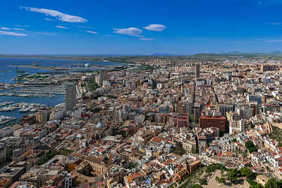
The growth shown in the draft is behind the coast, toward La Condomina and Alicante's remaining huerta, rather than on Playa de San Juan itself. The three sectors are meant to be planned together so roads, public facilities and open spaces don't stop at an arbitrary boundary.
Ciprés is the closest of the three to La Condomina and the proposed Parque de la Huerta. The August draft assigns it 1,552 homes across about 40.65 hectares, a density of 38 homes per hectare. This isn't an empty field. Detached houses, old paths and fragmented land ownership already occupy parts of the sector, which makes later land management more complicated than the headline suggests.
Vista Alegre, facing Avenida de Dénia, has the largest preliminary allocation: 1,958 homes on about 35.89 hectares, or 55 per hectare. Alameda, near the Avenida de Dénia and Avenida Pintor Pérez Gil axis, has 1,309 homes on roughly 30 hectares, or 44 per hectare. Together they are drawn as mixed districts, with housing alongside services and business uses rather than isolated bedroom estates.
The figures differ from earlier municipal material published in April, which used higher rounded estimates for some of the same sectors. That change is useful evidence in itself: these are working planning numbers. Buyers should date every claim they are shown and check it against the latest public document.
What Buyers Can Watch
Inland Supply
The proposed homes sit between established districts and the huerta, not in a new strip of beachfront construction.
Connections
Joint planning is intended to coordinate roads, walking routes and links between Avenida de Dénia, La Condomina and nearby districts.
Green Edges
The draft asks future plans to preserve green corridors and connect them with the proposed Parque de la Huerta.
Existing Owners
Ciprés already contains villas and divided ownership, so later reparcelation and phasing may be slow or contested.
For an owner in an established San Juan or Condomina community, the relevant questions are practical: which access road serves a future sector, where a green corridor meets the existing street network, and what construction traffic or new services might eventually follow. The PGE gives direction, not answers at plot level.
The same caution applies to promised schools, clinics and completion years. Alicante's wider plan reserves land for major public facilities and talks about health, education and transport uses around Avenida de Dénia. It doesn't give these three sectors confirmed opening dates for a particular school or health centre. Treat such dates as unannounced until a funded project and a competent authority publish them.
More planned supply can widen the choice for future buyers, especially families who want a modern apartment within reach of the beach but don't need a first-line address. It can also improve neglected connections if the infrastructure is delivered. Neither outcome belongs in today's valuation. Price an existing home for the street, condition, legal status and services it has now; treat the PGE as long-range context.
Read the Paper Trail
Identify the exact plot
Ask for the cadastral reference and sector name. 'Near Playa de San Juan' is too broad to establish planning status.
Ask which approval exists
A draft PGE, detailed sector plan, reparcelation approval and building licence are different milestones.
Verify through your lawyer
Have an independent lawyer check planning certificates, ownership, charges, guarantees and the licence before money becomes non-refundable.
Separate dates from estimates
Request the authority and document behind every claimed start, completion or public-facility date.
A licensed development should have a specific site, promoter, planning record and buyer protections that can be checked. A home shown only against the PGE's broad growth map has none of those merely because the map exists. Our new-build buying process explains the documents and guarantees to verify before signing.
If you're comparing this future belt with homes available now, use our Alicante property guide to compare established districts first. Then ask what the planned neighbourhood would give you that an existing address cannot, and how many years you're prepared to wait for that difference.
Buying in Alicante?
Compare the Plan With Homes Available Now
Start with established addresses and current services, then decide how much a future neighbourhood is worth to you.
Browse Alicante PropertiesTalk to a local broker
We live and work on Costa Blanca North — Jávea, Dénia and the towns around our office. We are a licensed estate agency, not only a guide: homes on our books, trusted partners for banking, legal, currency and other locations when you need them. Tell us where you are thinking of moving. No property shortlist required. We will help you find a sensible next step.
Talk to us